|
|
Post by Lady Frost on Feb 18, 2013 4:59:04 GMT -5
So, here is my second full map! Lots learned since the first. In fact, I dropped the previous "world" and started a new realm. The realm is Rhielôn and since the first world is gone I reused a few names I liked (if you happen to notice, that's why I did it). It is again based off the Forgotten Realms. This is the middle continent of Nordikana. It's surrounded by oceans with less-explored lands in the distance all around it (a bit like Faerûn). At the bottom is a full regional map so you can see the comparison. FYI: The Nordikana continent on the regional map isn't correct anymore. I added and moved things around some when I began the detailed version and haven't updated the regional map yet. Also, there isn't a key so I'll type it out here. 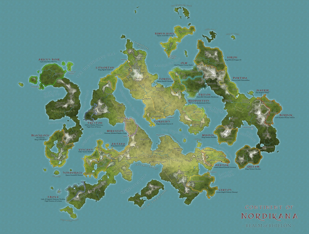 Key: The red names are official nations. The name under the nation's name is the current ruler. The nation's border color is based on the following: Orange = Kingdom (ruled by a monarch: king or queen) Yellow = Petty Kingdom (ruled by lesser royalty: prince, duke, etc...) Red = Stratocracy (ruled my military) Cyan = Republic (ruled by an elected official) Grey = Empire (group of regions ruled by an emperor, empress) (none shown) Blue = Theocracy (ruled by a deity, governed by their church) Purple = Plutocracy (ruled by the wealthy) Green = Magocracy (ruled by arcane spell casters) White = Aristocracy (ruled by elite citizens / nobles) Other symbols: Star = capital Circle = large metropolis (nothing smaller is represented for sake of space and sanity) (circles inside nations belong to the nation, circles outside are free city-states) Square = stronghold Triangle = point of interest Triple Red Dots = smaller, 'unofficial' regions of other races -- (D) Dwarf -- (H) Halfling -- (G) Gnome -- (E) Elf 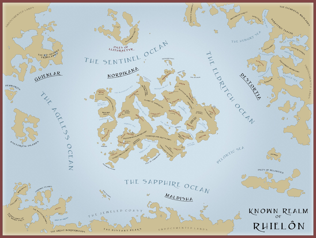 I feel like I can always keep adding more and more. It's hard to stop and say "I'm done". So I may add more later but for now I've convinced myself to stop. Let me know what you think! Thanks. edit:spelling |
|
|
|
Post by pattiiie on Feb 18, 2013 8:01:15 GMT -5
This is really neat, keep up the good work!
|
|
|
|
Post by Grozer on Feb 23, 2013 0:38:04 GMT -5
Very nice work, I especially like some of the names. To me that is always a tough thing, because well I always tend to reuse the ones that come to mind. Oh and by the way, so if you have time to do this then you have time to get in game?  |
|
|
|
Post by Lady Frost on Feb 23, 2013 4:10:23 GMT -5
Very nice work, I especially like some of the names. To me that is always a tough thing, because well I always tend to reuse the ones that come to mind. Oh and by the way, so if you have time to do this then you have time to get in game? Thanks! I'm trying, I'm waiting on my character to be put in. |
|
|
|
Post by DM Hawk on Feb 23, 2013 8:21:03 GMT -5
Before being drawn into online gaming I drew lots of maps of home brew worlds in my head, most in pencil on notebook paper. I eventually got a D&D map creation program and went a little crazy with it, being exceedingly proud of my work. All of which is humbled here. This is very neat, good work Lady Frost  |
|
|
|
Post by Grozer on Feb 23, 2013 10:59:21 GMT -5
Before being drawn into online gaming I drew lots of maps of home brew worlds in my head, most in pencil on notebook paper. I eventually got a D&D map creation program and went a little crazy with it, being exceedingly proud of my work. All of which is humbled here. Haha! Well we all know you are just a total nerd!  |
|
|
|
Post by Lady Frost on May 23, 2013 16:12:47 GMT -5
The nation of Xortaal. It's NE of the Nordikana Continent in the first map and is the only officially recognized nation on the Destortia Continent. You can see it on the 'known realms' map. I haven't decided its government type yet but I'll probably go with Stratocracy or Kingdom. Since I haven't given a scale yet, Xortaal is about 650 miles wide. For comparison, I'd say its square mileage is close to the Anauroch. It's large. As before, its all done from scratch in photoshop. 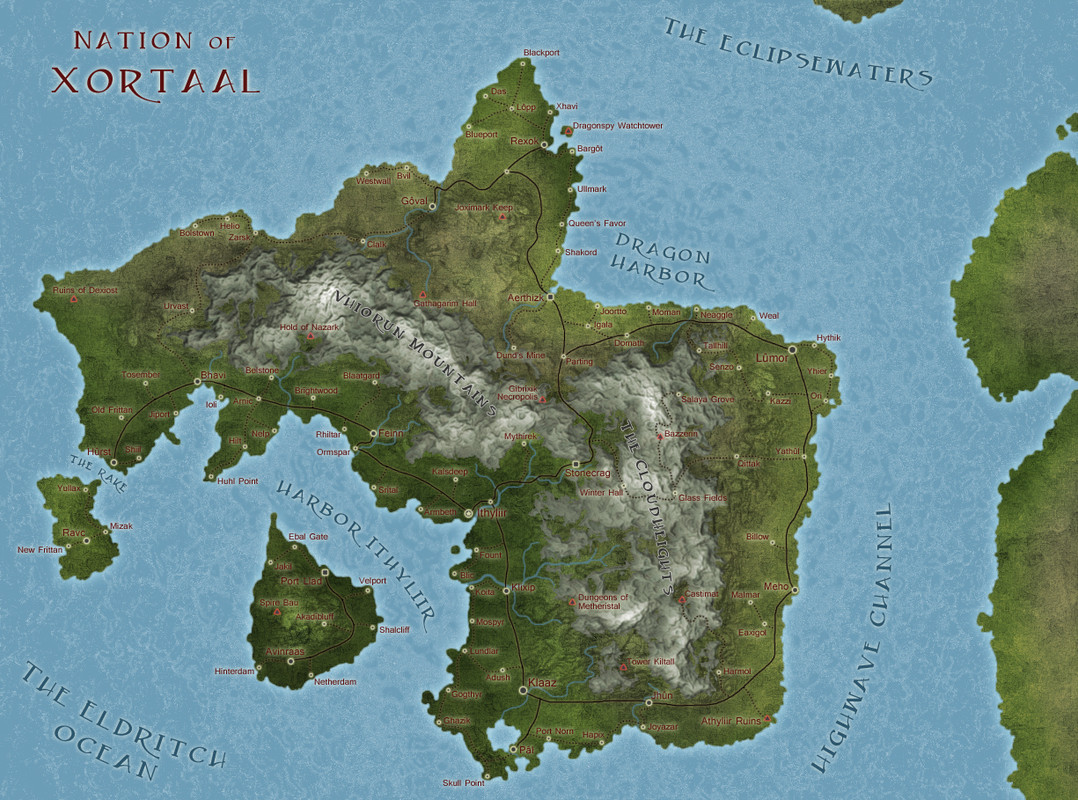 |
|
|
|
Post by DM Hawk on May 25, 2013 11:26:25 GMT -5
Beautiful work, Ladyfrost.
Seeing all the locations on the maps makes me think about a difficulty I often have. Do you find it challenging to come up all the names?
Coming up with fresh names for everything stumps my creative process sometimes.
|
|
|
|
Post by Duchess in Masquerade on May 25, 2013 12:52:58 GMT -5
Very nice work. |
|
|
|
Post by Lady Frost on May 25, 2013 19:19:53 GMT -5
Beautiful work, Ladyfrost. Seeing all the locations on the maps makes me think about a difficulty I often have. Do you find it challenging to come up all the names? Coming up with fresh names for everything stumps my creative process sometimes. It's actually fairly easy. I go through numerous places for this but here's an example. I take a Faerûn map and pick two names. Riatavin & Saelmur. Then I combine them into names and choose ones that I think fit into the theme I want. Rielmu Ratmur Tavinel Saeta Vinmur Atael Murrait Eltav and on and on... |
|
|
|
Post by Pedantry INC on May 27, 2013 7:34:10 GMT -5
These maps are amazing! I use that same method of naming, except instead of fr places I use the d&d draconic lexicon! haha |
|
|
|
Post by Lady Frost on Jun 17, 2013 16:40:58 GMT -5
The Trade Sea region. It's in the middle of the Nordikana continent (first map).  I wanted to try something different so this is my try at colorless using a brown tone. I like it but I miss color now. |
|
|
|
Post by Lady Frost on Sept 9, 2014 2:22:12 GMT -5
It's not part of my realm, but this is my latest map. It's actually the one I started right after the above one. I started last year and gave up after realizing the battle between my OCD and the combined amount of coastline, rivers and lakes in Canada might trigger some level of insanity. So a week ago I picked it back up and finished coloring the lakes. It'll eventually be an alternate history North America map. Unfortunately, I couldn't find what I wanted so I had to make my own. It'll probably be done in 2016.  postimg.org/image/y4cbobfqj/ postimg.org/image/y4cbobfqj/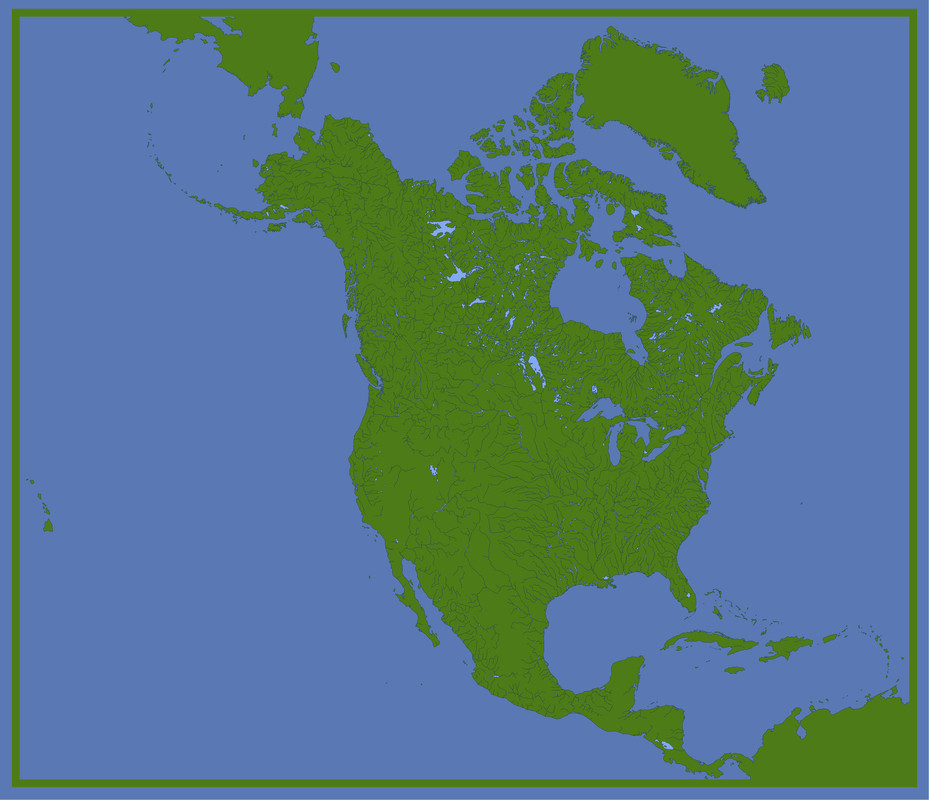 |
|
|
|
Post by Extropy on Sept 9, 2014 21:11:19 GMT -5
Are all those rivers accurate? That's quite detailed!
|
|
|
|
Post by Lady Frost on Sept 9, 2014 23:28:56 GMT -5
Are all those rivers accurate? That's quite detailed! Yea, everything is accurate. It's traced from a watershed atlas map. As a side note, it was incredibly interesting to see the watershed areas and how certain areas of the country all drain certain directions, and just how organized that mess of rivers actually is. i.imgur.com/FvcEx.gif |
|
|
|
Post by DOT on Sept 14, 2014 13:05:27 GMT -5
Very cool stuff . Can I ask what font you used? |
|
|
|
Post by Lady Frost on Sept 14, 2014 15:25:15 GMT -5
The red, nation font in the first map is Caeldera
The cities font in the Trade Sea map is French Script
|
|
|
|
Post by DOT on Sept 14, 2014 15:42:05 GMT -5
Thank you  |
|


